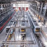
Thessaloniki gets ready for its metro launch in November
The underground rapid transit lines have been under construction for almost two decades due to various project delays
The underground rapid transit lines have been under construction for almost two decades due to various project delays
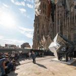
The cross pinnacle on the Tower of Jesus Christ will be ready to receive visitors in 2026 on the centennial of Gaudi’s death

Now you can get your wine in Talence by paying directly in Bitcoin

That’s because the state has to spend money on updating the railway infrastructure rather than subsidizing the cost of the popular pass

Steffen Romstöck said that he would respect the residents’ choice and would take over the helm of the municipality, even if he didn’t run

The measure, which will come into force from 1 January 2025, will be partial and temporary…for now
Rethinking renewable energy sources for the urban landscape

But operating them is still illegal under the country’s legislation

The examples, compiled by Beyond Fossil Fuels, can inform and inspire communities and entrepreneurs that still feel trepidation at the prospect of energy transition
Now you can get your wine in Talence by paying directly in Bitcoin
Rethinking renewable energy sources for the urban landscape
The examples, compiled by Beyond Fossil Fuels, can inform and inspire communities and entrepreneurs that still feel trepidation at the prospect of energy transition
The underground rapid transit lines have been under construction for almost two decades due to various project delays

Plus, it has a unique modular design that allows it to be shortened and lengthened like a train

At least, that’s the promise made by the mayor of Paris, Anne Hidalgo
Despite its church-y name, the district has long been known as the hangout spot for the artsy crowds
At least, that’s the promise made by the mayor of Paris, Anne Hidalgo
Hostal de Pinós is located in the geographical centre of the autonomous region

On the eve of the new academic year, the ranking considers several distinct but essential factors

Following a successful trial phase, these quiet areas will now be available on all main routes in the country

The academic institution shows a deeper understanding of the well-being of its students


Protohistory
Throughout the first millennium BC, thanks to favorable hydro-orographic factors, there was a unique culture appearing in the Northwest Peninsular in its peculiar habitat and archaism of its forms, polarized around fortified villages, occupying the tops of hills and spurs cliffs, commonly called castros.
Hence the designation of «Cultura Castreja», which will be, perhaps, one of the most particular and interesting phenomena of humanization of the landscape, to which the municipality of Lousada is not alien.
With affiliation in this period, that is, with proven occupation between the Late Bronze Age and the first decades of the 1st century AD, 16 villages are known to have existed in the county, with the São Domingos (Cristelos) castro being the most prominent due to both its strong visual impact on the surrounding landscape and its defensive apparatus with four wall girdles, which translates into an occupational surface that covers around 16 hectares.
The data currently available makes it possible to count in Lousada 5 villages with occupation of the Final Bronze, namely: Alto dos Três Caminhos and Chã de Bouça das Cales, located in the Sousa river watershed; Cabeço da Agrela, Alto das Cadeiras and Castro dos Mortório, located in the hydrographic basin of the Mezio River.
Roman Period
As is the case with the whole Sousa basin region, the municipality of Lousada was also subject to intense romanization.
The Northwest Peninsular, was under the administrative control of Tarraconensis, the largest of the Hispanic provinces, with its capital in Tarraco. Its borders were defined to the southwest with Lusitânia and Baetica and to the northeast with Gaul Aquitaine and Gaul Narbonense, the rest being confined by the Atlantic. Within the Tarraconensis province, the northwest was organized into 3 conventi, with the Conventus Bracaraugustanus being particularly interesting, with the capital at Bracara Augusta (Braga) and its southern boundaries crossing the Douro.
Middle Ages and Modern Age
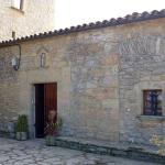
Archaeological references and elements associated with religion and popular devotion are the most representative of this period in Lousada, as are the countless churches and chapels of Romanesque tradition, among which the church of Meinedo, the church of Aveleda and the church of S. Miguel.
Dating from the same period, one can also find the Cerca dos Veados (Vilar do Torno and Alentém) lagareta - a piece of infrastructure that attests to the production of wine in the Middle Ages in this part of the territory of Portugal.
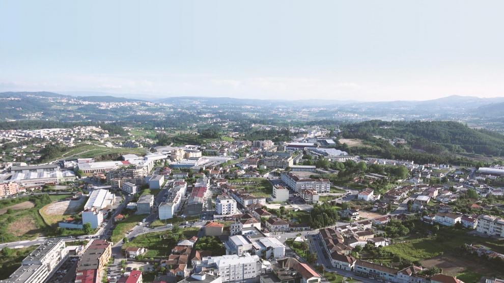
The municipality of Lousada is located in the northwest of Portugal - a natural unit defined by the predominance of Atlantic characteristics, in the geographical region of Minho, located in the heart of the district of Porto.
It has an area of 94.89 km², which is subdivided into 25 parishes. The population consists of 47,387 people (2011).
The economic matrix of the municipality of Lousada is strongly marked by agriculture. Although the development of other economic sectors is beginning to assert itself, namely textiles and, more recently, the reorganization of wine production.
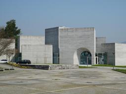
Tourism in Lousada is a growing sector. With many points of interest in terms of heritage, cultural and sports facilities, handicrafts, gastronomy and a number of events of various kinds, the municipality has plenty to offer and is capable of attracting a high number of visitors and tourists.

